
Seismic zones in Western Canada
Background on Earthquakes in Western Canada
Each year, seismologists with the Geological Survey of Canada record and locate more than 1000 earthquakes in western Canada. The Pacific Coast is the most earthquake-prone region of Canada. In the offshore region to the west of Vancouver Island, more than 100 earthquakes of magnitude 5 or greater (large enough to cause damage had they been closer to land) have occurred during the past 70 years. Part of the Pacific Ring of Fire, the concentration of earthquakes along the west coast is related to the presence of active faults, or breaks in the earth's crust. The surface of the earth is always changing, as the earth's crust is made up of "plates" (like pieces of a jigsaw puzzle) that are constantly moving relative to one another at speed's of about 2-10 cm/year (about how fast your fingernails grow). The plates can either slide past one another, or they can collide, or they can diverge (or move apart).
The west coast of Canada is one of the few areas in the world where all three of these types of plate movements take place, resulting in significant earthquake activity. Earthquakes in this region occur along the faults in the offshore region (e.g., the M=8.1 Haida Gwaii earthquake of 1949); within the subducting ocean plate (e.g., a magnitude 6.5 earthquake beneath downtown Seattle in 1965); and within the continental crust (e.g., a magnitude 7.3 earthquake on central Vancouver Island in 1946). Moving inland from the coast (and the active plate boundaries), the frequency and size of the earthquakes decreases. Saskatchewan and Manitoba are the least earthquake-prone areas in Canada.
- Offshore BC Region
- Cascadia Subduction Zone
- St. Elias Region and the Southwestern Yukon
- Northern Cordillera
- Southern Cordillera
- Interior Platform
Offshore Region
From northern Vancouver Island, to the Haida Gwaii (formerly Queen Charlotte Islands), the oceanic Pacific plate is sliding to the northwest at about 6 cm/year relative to North America. The boundary between these two giant plates is the Queen Charlotte fault - Canada's equivalent of the San Andreas fault. Canada's largest historical earthquake- a magnitude 8.1, occurred along this fault on August 22, 1949. This earthquake, larger than the 1906 San Francisco earthquake, caused nearly a 500-km-long segment of the Queen Charlotte fault to break.
Cascadia Subduction Zone
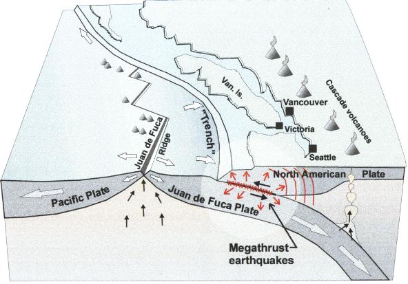
West of Vancouver Island, and extending from the north tip of the Island to northern California, the oceanic Juan de Fuca plate is moving towards North America at about 2-5 cm/year. This region is called the Cascadia subduction zone. Here, the much smaller Juan de Fuca plate is sliding (subducting) beneath the continent (it is about 45 km beneath Victoria, and about 70 km beneath Vancouver). The ocean plate is not always moving though. There is good evidence that the Juan de Fuca and North America plates are currently locked together, causing strain to build up in the earth's crust. It is this squeezing of the crust that causes the 300 or so small earthquakes that are located in southwestern British Columbia each year, and the less-frequent (once per decade, on average, damaging crustal earthquakes (e.g., a magnitude 7.3 earthquake on central Vancouver Island in 1946). At some time in the future, these plates will snap loose, generating a huge offshore "subduction" earthquake - one similar to the 1964 M=9.2 Alaska earthquake, or the 1960 M=9.5 Chile earthquake. Current crustal deformation measurements in this area provide evidence for this model. Geological evidence also indicates that huge subduction earthquakes have struck this coast every 300-800 years.
St. Elias Region and the Southwestern Yukon Territory
The St. Elias region of the southwest Yukon Territory, northwest British Columbia, and southeast Alaska is one of the most seismically active areas in Canada. Here, the plate boundary between the giant Pacific and North American plates is changing from one of transform (sliding past one another), to subduction (where the Pacific plate is being forced beneath the Aleutian Islands to the northwest). This results in very rapid uplift rates (mountain building) of up to 30 mm/year. The area of the plate margin has experienced many large earthquakes, including a sequence of three earthquakes of magnitude 7.4 to 8.0 in the year 1899. In 1958 a magnitude 7.9 earthquake occurred along the Fairweather fault (the northern extension of the Queen Charlotte transform fault). The most significant inland zone of seismicity follows the Dalton and Duke River segments of the Denali fault zone through the southwest Yukon. Farther inland, there is minor seismicity between the Denalli and Tint ina fault systems. The rate of seismic activity increases at the eastern edge of the cordillera (see below).
Northern Cordillera
The northern Rocky Mountain region is one of the most seismically active areas of Canada. The largest earthquake recorded in this area, to date, is the magnitude 6.9 earthquake of December 23, 1985 in the Mackenzie mountains of the Northwest Territories. Magnitude 6-plus earthquakes have occurred in the Richardson Mountains of the Yukon Territory (M=6.2 in May, 1940; M=6.5 in June, 1940, and M=6.6 in March, 1955).
Southern Cordillera
South of 60 N, seismicity in the interior and Rocky Mountain areas drops off rapidly. The largest earthquake recorded in the southern Cordillera was a magnitude 6.0 in 1918 that struck the Valemount area of the Rocky Mountain trench. In 1986 a magnitude 5.5 earthquake occurred near Prince George, causing some minor damage.
Interior Platform
Seismic activity in the prairie region south of 60 N is predominantly confined to southern Saskatchewan in a zone that continues into Montana. The largest earthquake ever recorded in this area was a magnitude 5.5 event on May 15, 1909 near the Canada - United States border. Small, induced earthquakes associated with potash mining in southern Saskatchewan are sometimes recorded.